Boonie Stomp

ENJOY THESE EVENTS AS THEY HAPPEN ACROSS MICRONESIA!
E.g., 04-19-2024
E.g., 04-19-2024
*Choose booth start and end dates
GUAM

Boonie Stomps - Togcha River

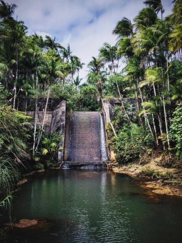
November 26    Togcha River     Difficult     3 miles
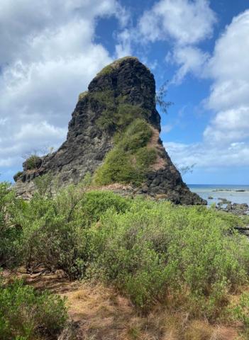
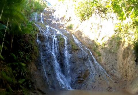
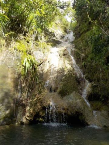
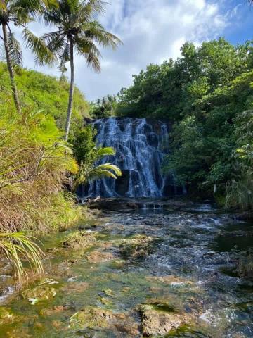
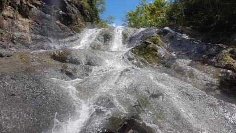
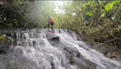
We travel through the river and vegetation to find caves & waterfalls
We will head up the Togcha River, going over and under vines, roots, and through mud. Along the way we will explore a few caves and then some waterfalls.
Special Conditions: Crawling through mud, steep slopes up and down, river walking, cave exploring, and Fire Ants.
Bring: 3 liters water, sturdy shoes that can get wet, sun screen, insect repellent, lunch, headlamp, and camera. Long sleeves with hood and pants recommended for fire ants.
Special conditions: Sword grass, river crossing, rope climb, and a muddy swamp
Parking Location: Google Maps or Apple Maps: 13.369352, 144.752569 (side of the road)
GUAM

Boonie Stomps - Fouha

November 19    Fouha     Medium     1.5 miles
Explore an area that has a significant part in one of Guam’s most enduring legends.
We will head down a trail that will pop us right out onto the beach. From there we will journey to this legendary Fouha Rock. If the tide is right, we will continue to the pools to do some swimming. Very Kid friendly!
Special conditions: Rope climbing, steep slopes, slippery mud, and walking in water.Bring: 2 quarts water, hiking shoes, gloves, sun screen, snacks, and camera (Snorkel and/or kids floaters to swim if tide is right)
Parking Location: Google Maps or Apple Maps: 13.419824585379395, 144.74604817322555 (down the road from theSpecial Conditions: Possible mud, walking through water, and steep slope up and down.
Parking Location: Google Maps or Apple Maps: 13.301649, 144.658951 (side of the road)
GUAM

Boonie Stomps - Sinisa, Baby, Hidden & Lower Sigua Falls

November 12    Sinisa, Baby, Hidden & Lower Sigua Falls     Very Difficult     6 miles
We travel to four beautiful waterfalls.
We then hike along two rivers with many smaller waterfalls to end up at Lower Sigua Falls for jumping and swimming. Bring: 4 quarts water, get wet shoes, swimsuit, gloves, sun screen, sunglasses, insect repellent, lunch, snacks, and camera.
Special conditions: Rope climbing, steep slopes, slippery mud, and walking in water.
Parking Location: Google Maps or Apple Maps: 13.419824585379395, 144.74604817322555 (down the road from the Entrance to Leos Palace, on the side of the road)
GUAM

Boonie Stomps - Ben’s Falls

November 5    Ben’s Falls     Double Difficult     4 miles
We journey to a beautiful series of waterfalls.
This is a nice hike that offers a great set of waterfalls in a little known, cool green valley. We will then journey up the mountain, through sword grass, a limestone forest, and visit Lam Lam before heading down & back to the car.
Bring: 4 quarts water, sturdy hiking shoes that can get wet, gloves, sun screen, sunglasses, insect repellent, lunch, and camera
Special Conditions: Walking in water through rocky river, steep slopes through sword grass, and climbing waterfalls with a rope. Lots of Mosquitos!
Parking Location: Google maps or Apple Maps - 13.337333936813977, 144.6590289153706 (Sella Bay Overlook)
GUAM

Boonie Stomps - Madofan to Facpi Point

September 24         Madofan to Facpi Point        Very Difficult        5 miles
We hike down the southwestern savannah to a series of three large waterfalls on the Madofan River, then walk the beach to Facpi Point for spectacular views and head uphill through the jungle and up & out old jeep trails.
Bring: 4 quarts water, get wet shoes, gloves, sun screen, insect repellant, lunch and snacks Special Conditions: Sword grass, steep hills, walking in water, mud, sword grass and steep slopes up, beach hike.
Parking Location: Google Maps or Apple Maps: 13.344444, 144.655484 (Side of the road)
GUAM

Boonie Stomps - Aguada

September 17    Aguada    Very Difficult     5 miles
We traverse a long steep and grassy ridge in western Guam to a large and picturesque waterfall. There are several smaller falls and swimming spots along the way.
Bring: 4 quarts water, get wet shoes, gloves, sun screen, lunch and snacks, and camera.
Bring a small blow up inner tube incase the water is deep we will drift down the river.
Special Conditions: Extensive walking in water, mud, slippery rocks, uphill climbs. Parking Location: Google Maps or Apple Maps: 113.452903411944149, 144.7163409938642 (San Carlos Trailhead)
GUAM

Boonie Stomps - Fonte Dam

September 10      Fonte Dam      Easy      2 miles
A gently sloping downhill trail, followed by a flat muddy patch, leads to the top of the large brick dam. Climbing down the steep trail beside the dam with the help of ropes we reach the bottom. Crossing the river we climb up the possibly muddy trail to the top of the other ridge. Coming out on an open windy ledge there is an outstanding view north towards the airport and beyond. A short but steep trail leads down to the river's edge and a short walk downstream, past the spider man challenge, leads to the swim hole and short jump at the small waterfall.
Bring: 2 quarts water, electrolytes, get wet shoes, sun screen, sunglasses, lunch and snacks, and camera Special Conditions: Muddy, mosquitoes, river walking
Parking Location: Google Maps or Apple Maps: 13.46260973680986, 144.72895498169234 (side of road)
GUAM

Boonie Stomps - Fintasa & Lao Lao

September 3      Fintasa & Lao Lao       Medium       2 miles
We journey to 2 cooling waterfalls in southeastern Guam. Enjoy swimming and waterfall showers at the scenic Fintasa Falls, then return to the original river crossing to head downstream to the open ledges, swim holes, and waterfalls of Laolao Falls.
Bring: 2 quarts water, hiking shoes, swimsuit, gloves, sun screen, lunch, and camera
Special Conditions: Some walking in water, fairly steep hills to climb and descend, sword grass.
Parking Location: 13.287430, 144.743071 (Roadside by Inarajan Middle School)
GUAM

Boonie Stomps - Upper Imong

August 27    Upper Imong    Very Difficult    5 miles
We trek to a new waterfall along the Imong River. Heading up the rain gauge trail, we’ll turn south on the Southern mountains trail. Turning east, we’ll head steadily downhill through open savannah and sword grass to a long river cascade and an impressive multi tier waterfall.
Bring: 4 quarts water, hiking shoes, gloves, swim suit, sun screen, lunch and snacks, and camera.
Special Conditions: Possible mud, sword grass, steep slopes up and down, river walk and a long hike.
Parking Location: Google Maps or Apple Maps: 13.323499, 144.672544 (Southern Mountain Overlook)
GUAM

Boonie Stomps - Bubulao Falls

August 20    Bubulao Falls     Difficult    4 miles
We hike down the Ugum River to a side stream to Bubulao Falls, then continue on to the top of Talofofo Falls, passing many falls, rapids, cascades, and swim holes on the river.
Bring: 2 quarts water, get wet shoes, gloves, sun screen, lunch and snacks, and camera. Bring a small blow up inner tube incase the water is deep we will drift down the river.
Special Conditions: Extensive walking in water, deep over head water, slippery rocks.
Parking Location: Google Maps or Apple Maps: 13.314785355588043, 144.73346513050413 (side of road)

Pages